
 sparteek65

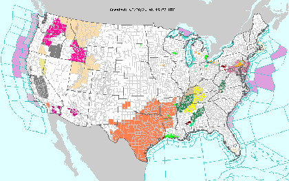
Laura is losing tropical characteristics as it is losing power this afternoon but heavy rain, flooding, and severe storms with tornadoes and damaging winds remain possible from the Tennessee Valley to the west-central Gulf Coast. Severe thunderstorms are also likely across the Midwest and Great Lakes into the Ohio Valley and Mid-Atlantic region.WATCHES AND WARNINGSFlash Flood Watches are posted for portions of northeast Arkansas,southeast Missouri, western Kentucky and Tennessee, northern of Mississippi, and northwest Alabama.There are no coastal watches or warnings in effect.Weather OutlookAt 1000 AM CDT (1500 UTC), the center of Tropical Depression Laurawas located near latitude 36.6 North, longitude 90.5 West. Thedepression is moving toward the east-northeast near 20 mph (31 km/h)and this motion is expected to continue as Laura tracks alongand south of the Ohio Valley through tonight.Maximum sustained winds are near 30 mph (45 km/h) with highergusts. Eventually, the remains of Laura will cross the centralAppalachians Saturday, before becoming absorbed by an approachingcold front that is forecast to move off the mid-Atlantic coastlineby late Saturday.The estimated minimum central pressure is 1001 mb (29.56 inches).
Expect 1 to 3 inches, with isolated 5 inch totals from
western and central Kentucky and Tennessee into northern Alabamaand Mississippi. One to 2 inches, with isolated 4 inch totalsare possible over southern parts of Louisiana, Mississippi, andAlabama. By Saturday, 1 to 3 inches of rain is forecast from thecentral and southern Appalachians to the mid-Atlantic states.This rainfall will continue to contribute to isolated flash andurban flooding, and overflow of small streams and creeks across theaforementioned regions. Minor to moderate river flooding isoccurring or forecast in Louisiana and Arkansas.WIND: Gusty winds of 25-30 mph will accompany Laura�s circulationas it moves toward the Lower Ohio Valley through the afternoon.Stronger gusts are possible within thunderstorms.
TORNADOES: A few tornadoes remain possible, mainly over parts of
Mississippi, Tennessee and southern Kentucky. The risk for a coupleof tornadoes should redevelop Saturday afternoon and evening overparts of the mid-Atlantic from Virginia to North Carolina